Alles Neu! Everything New!
Hier finden Sie die Texte der Ausstellung "Alles Neu" Hannover 1965-1975". Here you can find the texts of the exhibition "Everything New" Hannover 1965-1975".
Hier finden Sie die Texte der Ausstellung "Alles Neu" Hannover 1965-1975". Here you can find the texts of the exhibition "Everything New" Hannover 1965-1975".
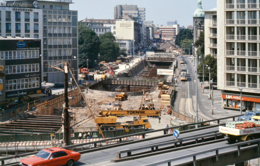
Das große Loch
Das große Loch – so wurde die Grube für den Bau der U-Bahn zwischen Waterlooplatz und Hauptbahnhof genannt. Die Baustelle wanderte von 1965 bis 1975 durch die gesamte Innenstadt und verursachte einen permanenten Ausnahmezustand. Baulärm, Tempolimits und Verkehrsumleitungen bestimmten das Leben in der City. Viele Geschäftsleute machten sich Sorgen, dass ihnen die Baustelle die Kund*innen abgraben würde.
Nach 10 Jahren war es geschafft. Die Stadtbahn fuhr nun unterirdisch, während oben eine weitreichende Fußgängerzone geschaffen wurde. Zwischen Hauptbahnhof und Kröpcke entstand die „Passerelle“ – eine unterirdische, nach oben offene Einkaufsmeile (heute “Niki-de Saint-Phalle-Promenade”).
The big hole
The big hole – that's what they called the excavation pit for the construction of the subway between Waterlooplatz and the main train station. From 1965 to 1975, the construction site moved through the entire city center, causing a permanent state of disruption. Construction noise, speed limits, and traffic diversions shaped daily life in the city. Many business people were concerned that the construction site would drive away their customers.
After 10 years, the work was finally done. The subway now ran underground, while a large pedestrian zone was created above. Between the main station and Kröpcke, the “Passerelle” was built – an underground open-roof shopping promenade (today known as the “Niki de Saint-Phalle Promenade”).
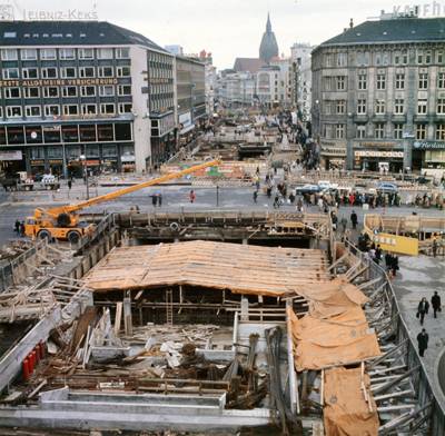
Neues Zentrum
Auf das Stadtzentrum wirkte sich der U-Bahnbau besonders stark aus. Rund um den Kröpcke als Stadtmittelpunkt entstand eine Fußgängerzone. Die Neugestaltung des Platzes war die Folge und zentraler Baustein dafür war das Kröpcke Center – ein gewaltiger Hochhausturm. Der zuvor an dieser Stelle stehende „Conti-Block“, ein provisorischer Ladenkomplex der Nachkriegszeit, wurde dafür abgerissen.
Das Kröpcke Center wurde von 1971 bis 1973 erbaut. Das Ziel war, einen multifunktionalen Komplex als Kaufhaus, Bürogebäude, Verwaltungszentrum und Verkehrsknotenpunkt direkt über dem neuen U-Bahn-Knoten Kröpcke zu schaffen. Mit vergleichbaren Zielen entstanden nahezu zeitgleich das Ihme Zentrum und das Lister Tor Hochhaus am Raschplatz. Allerdings gab es immer auch Kritik an der Größe, dem Baustil und mangelnder Funktionalität des Kröpcke Center.
Im Jahr 2014 wurde der Komplex in ein modernes Geschäftshaus umgebaut, das eine deutlich niedrigere Höhe hat. Bei den Sanierungsarbeiten verschwand auch das auf dem Foto zu sehende „Kröpcke-Loch“, ein Teil der unterirdischen „Passerelle“.
New City center
The construction of the subway had a particularly strong impact on the city center. A pedestrian zone was created around Kröpcke, the heart of the city. This resulted in the redesign of the square, and the Kröpcke Center as a central element of it – a huge high-rise tower. The “Conti Block,” a temporary post-war shopping complex that had previously stood on this site, was demolished to make way for it.
The Kröpcke Center was built between 1971 and 1973. The aim was to create a multifunctional complex combining a department store, office building, administrative center, and transport hub
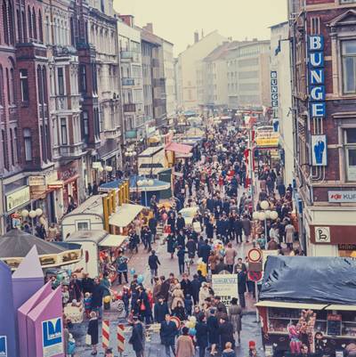
Bahnhofstraße
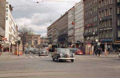
Ein heute ungewohnter Anblick: die Bahnhofstraße mit Autoverkehr und ohne die „Niki-de Saint-Phalle-Promenade“. Eine Fußgängerzone ist die Bahnhofstraße erst seit 1975. Zuvor waren Bahnhofstraße und Kröpcke viel befahrende Verkehrsknotenpunkte, da Autos, Straßenbahnen und Fahrräder mitten durch das Stadtzentrum geleitet wurden. Pläne, den Innenstadtkern vom Verkehr zu entlasten, gab es schon seit den 1950er Jahren. Die Einrichtung des „City Rings“ gehörte dazu. Voll umgesetzt wurden sie aber erst nach Fertigstellung der U-Bahnverbindung zwischen Waterlooplatz und Hauptbahnhof.
Angelegt wurde die Straße 1843 zusammen mit dem Bau des ersten Bahnhofs und der Stadterweiterung zwischen Bahnhof und Kröpcke.
Bahnhofstraße
An unusual sight today: Bahnhofstraße with car traffic and without the "Niki de Saint Phalle Promenade." Bahnhofstraße has only been a pedestrian zone since 1975. Before that, both Bahnhofstraße and Kröpcke were busy traffic junctions, as cars, trams, and bicycles passed directly through the city center. Plans to reduce traffic in the city center had existed since the 1950s. One of these was the creation of the “City Ring.” However, these plans were only fully implemented after the completion of the subway connection between Waterlooplatz and the main train station.
The street was laid out in 1843, along with the construction of the first train station and the city’s expansion between the station and Kröpcke.
Lister Meile
Die Lister Meile erhielt ihren Namen am 16.11.1972. Zur Einweihung gab es ein großes Straßenfest. Ihre Existenz verdankt die Lister Meile dem U-Bahnbau zwischen Hauptbahnhof und Lister Platz 1968-1972.
Die neue U-Bahnstrecke sollte die Gegend „hinter dem Bahnhof“ besser mit der City verbinden und damit eine zusammenhängende Einkaufszone erschaffen. Zugleich sollten Straßenbahn- und Autoverkehr voneinander getrennt werden. Ein Teil der Straßen sollte zukünftig Fußgängerzone werden, ein anderer Teil verkehrsberuhigt. Bürgermeister Otto Barche träumte „von der Zeit, in der ein Einkaufsbummel von der Marktkirche bis zum Lister Platz möglich sein wird.“
Dabei hatte das Projekt anfangs viele Gegner. Geschäftsleute machten sich Sorgen um Umsatzeinbußen, wenn Kundinnen und Kunden ihre Autos nicht mehr direkt vor dem Geschäft parken konnten. Ladenbesitzende und Anwohnende schlossen sich zu einem Verein zusammen (später: Aktion Lister Meile e.V.). Der Verein war sowohl Kritiker, als auch Partner des Projektes und spielte bei der Etablierung der Lister Meile eine entscheidende Rolle.
Lister Meile
Lister Meile received its name on November 16, 1972. A large street festival was held to celebrate its inauguration. Lister Meile owes its existence to the construction of the subway between the main station and Lister Platz between 1968 and 1972.
The new subway line was intended to better connect the area “behind the station” with the city center, thereby creating a continuous shopping zone. At the same time, tram and car traffic were to be separated from each other. Part of the streets were to become pedestrian zones, while others were to be traffic-calmed. Mayor Otto Barche dreamed “of the time when a shopping stroll from the Market Church to Lister Platz would be possible.” However, at the beginning, the project faced many opponents. Business owners were concerned about loss of revenue if customers could no longer just park their cars right in front of the store.
Shop owners and residents formed an association (later: Aktion Lister Meile e.V.). The association was both a critic and a partner of the project and played a decisive role in establishing the Lister Meile.
Der Roderbruch
Die Entwicklung des Stadtteils Roderbruch ist eng mit der Entstehung der Medizinischen Hochschule Hannover verbunden. Als zu Beginn der 1960er Jahre überlegt wurde, wo eine so große Einrichtung wie die MHH ihren Platz finden soll, fiel die Entscheidung schnell auf den Roderbruch. Denn hier konnte zugleich ein neues Wohngebiet nebenan entstehen – zum Beispiel für die Angestellten.
Das neue Wohngebiet sollte auch eine Schule erhalten. Die Schulform Integrierte Gesamtschule entstand damals als neues Konzept in Niedersachsen: Sie sollte eine größere Durchlässigkeit zwischen den bisherigen Schulformen ermöglichen. 1973 eröffnete die IGS Roderbruch und war damit der erste Neubau für eine IGS.
So wurden im Roderbruch also ab 1965 innerhalb weniger Jahre die IGS, die MHH als Campushochschule auf rund 400.000 Quadratmeter und eine gesamte neue Großwohnraumsiedlung mit bis zum 19-geschossigen Hochhäusern gebaut.
Roderbruch
The development of the Roderbruch district is closely linked to the establishment of Hannover Medical School (MHH). When, at the beginning of the 1960s, it was being considered where such a large institution as the MHH should be located, the decision was quickly made in favor of Roderbruch. Because here a new residential area could be built next door – for example, for the employees.
The new residential area was also to include a school. The school type “Integrierte Gesamtschule” (Integrated Comprehensive School) emerged at that time as a new concept in Lower Saxony: it was intended to provide greater permeability between the existing types of school. In 1973, the IGS Roderbruch opened, making it the first new building for an IGS.
Thus, starting in 1965, within a few years, the IGS, the MHH as a campus university covering around 400,000 square meters, and an entire new large residential area with high-rise buildings up to 19 stories high were built in Roderbruch.
Altstadtfest
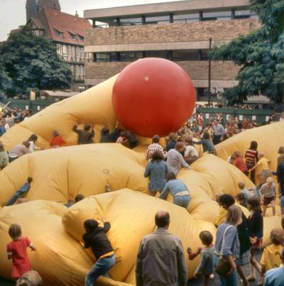
Das erste Altstadtfest fand 1970 unter dem Motto „dabeisein und mitmachen“ statt und war Auftakt des „Experiments Straßenkunst“. Es sollte dabei helfen, die Straßenkunst bekannter und beliebter zu machen und dem Image der Stadt als grau und langweilig entgegenstehen. So wurde das Fest zum Schauplatz zahlreicher verschiedener künstlerischer Perfomances und es entwickelte sich schnell zu einer der beliebtesten Veranstaltungen im Jahr.
In der gesamten Altstadt gab es verschiedene künstlerische Installationen und Aktionen, Konzerte und andere Unterhaltungsprogramme zum Erleben und mitmachen. Eines der Highlights waren die Babbelplast-Ballons, bewegliche mit Luft befüllte Konstruktionen von Klaus von Illusta.
Old Town Festival
The first Old Town Festival took place in 1970 under the motto “be there and join in” and marked the start of the “street art experiment.” Its aim was to help make street art better known and more popular, and to counter the city's reputation as gray and boring. The festival quickly became a stage for a wide range of artistic performances and soon developed into one of the most popular events of the year.
Throughout the entire old town, there were various artistic installations and activities, concerts, and other entertainment programs to experience and participate in. One of the highlights were the Babbelplast balloons, movable air-filled constructions created by Klaus von Illusta.
Das Stadionbad
Das Stadionbad eröffnete im Jahr 1972. Es ist ein Bestandteil des Sportparks, der seit den 1950er Jahren in der Calenberger-Neustadt direkt am Maschsee entstand. Der Sportpark war Teil der städtischen Strategie, in den verschiedenen Stadtteilen größere Bezirkssportanlagen für viele verschiedene Sportarten zu bauen, anstelle vieler kleiner Sportplätze.
Wie im gesamten Sportpark, steht daher auch im Stadionbad nicht nur der Leistungs- und Wettkampfsport, sondern vor allem der Breitensport im Zentrum. Im Stadionbad finden also Schwimm- und Wasserballwettkämpfe statt, aber auch Schwimmkurse und Unterwassersport für alle.
The stadium pool
The stadium pool opened in 1972. It is part of the sports park that had been developed in Calenberger-Neustadt, right next to the Maschsee, since the 1950s.
The sports park was part of the city's strategy to build larger district sports facilities for a wide range of sports in different neighborhoods, instead of many small sports fields.
As in the entire sports park, the focus at Stadionbad is not only on competitive and high-performance sports, but above all on recreational sports. So while swimming and water polo competitions are held at Stadionbad, it also offers swimming courses and underwater sports for everyone.
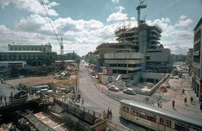
Die „Stadt in der Stadt“
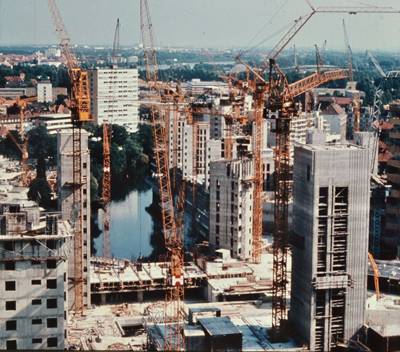
Im Zuge der Neu-Planung der Innenstadt während des U-Bahnbaus sollte die Innenstadt enger mit den angrenzenden Wohngebieten verbunden werden. Der Plan war, die Stadt weiter zu verdichten – mit multifunktionalen Großkomplexen.
Angedacht waren solche Gebäudekomplexe rundum die Innenstadt am Steintor, Raschplatz, Aegi, Kröpcke und in Linden an der Ihme. Letztendlich wurden nur drei davon geplant und von privaten Investoren in unterschiedlichen Dimensionen umgesetzt: Das Kröpcke-Center, das Lister Tor am Raschplatz und das Ihme-Zentrum.
Das Ihme-Zentrum wurde zwischen 1971 und 1975 auf dem ehemaligen Gelände der Mechanischen Weberei Linden gebaut, fast dreifach so groß wie ursprünglich von der Stadt geplant. Doch obwohl schon vor Beginn der Bauarbeiten mehr als die Hälfte der Wohnungen verkauft worden waren, war die „Stadt in der Stadt“ von Beginn an umstritten – nicht zuletzt wegen des brutalistischen Baustils.
Auch unter den Bewohner*innen des Ihme-Zentrums wuchs die Unzufriedenheit und Leerstand und Sanierungsbedarf wurden immer größer. Immer wieder gab es Versuche verschiedener Investoren, den Komplex zu sanieren und neuzugestalten. Doch bisher sind alle Vorhaben gescheitert und die Zukunft des Ihme-Zentrums ist weiterhin ungewiss.
The “city within a city”
As part of the redevelopment of the city center during the construction of the subway, the city center was to be more closely connected to the surrounding residential areas. The plan was to further densify the city with large multifunctional complexes.
Such building complexes were envisioned around the city center at Steintor, Raschplatz, Aegi, Kröpcke, and in Linden on the Ihme River. In the end, only three of them were planned and realized by private investors in varying extents: the Kröpcke Center, the Lister Tor at Raschplatz, and the Ihme Center.
The Ihme Center was built between 1971 and 1975 on the former site of the Linden mechanical weaving mill, nearly three times larger than originally planned by the city. But although more than half of the apartments had been sold before construction began, the “city within a city” was controversial from the outset – not least because of its brutalist architectural style.
Even among the residents of the Ihme Center, dissatisfaction grew over time – partly due to architectural problems and a sense of anonymity. The shops struggled to survive, and vacancies and need for renovations became increasingly apparent. Various investors attempted to renovate and redesign the complex. However, all efforts have failed so far, and the future of the Ihme Center remains uncertain.
Straßenkunst und Altstadtflohmarkt
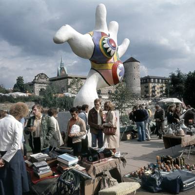
Die bunten Nana-Figuren der Künstlerin Niki de Saint Phalle wurden 1974 am Leineufer aufgestellt – als Höhepunkt des „Experiments Straßenkunst“, das 1970 ins Leben gerufen wurde. Mit dem entsprechenden Ratsbeschluss wurde die Förderung von Kunst im öffentlichen Raum erstmals in Deutschland zur politischen Aufgabe erklärt. Martin Neuffer, der damalige Oberstadtdirektor, hatte „eine farbige Stadt, die mit Kunstwerken so vollgestopft ist, wie mit Bäumen“ vor Augen.
Ziel des Projekts war es, Hannovers Attraktivität und das Lebensgefühl in der Stadt nach dem Neuaufbau zu steigern – vor allem in der Altstadt. Die Idee der „Straßenkunst“ war sehr beliebt, trotzdem sorgte die Auswahl einiger Kunstwerke auch für Kritik und Diskussionen – vor allem die Nanas. Dabei zählen sie heute zu den beliebtesten Wahrzeichen der Stadt.
Der Altstadtflohmarkt fand 1967 zum ersten Mal auf dem Holzmarkt statt und sollte ursprünglich auch zur Wiederbelebung der Altstadt beitragen. Die Idee funktionierte: Schnell wurde er so beliebt, dass der Holzmarkt nicht mehr ausreichte. Seit 1972 und bis heute findet der Flohmarkt regelmäßig am Leineufer statt.
Street art and the Old Town flea market
The colorful Nana sculptures by artist Niki de Saint Phalle were installed on the banks of the Leine River in 1974—the highlight of the “Street Art Experiment” launched in 1970. With the corresponding resolution by the city council, the promotion of art in public spaces was, for the first time in Germany, declared a political task. Martin Neuffer, then Chief Municipal Director, envisioned “a colorful city as full of artworks as it is of trees.”
The aim of the project was to enhance Hanover's appeal and the quality of urban life after the post-war reconstruction – especially in the Old Town
The idea of “street art” was very popular, though the selection of certain artworks also sparked criticism and debate – especially the Nanas. Today, however, they are among the city's most popular landmarks.
The Old Town Flea Market took place for the first time in 1967 at the Holzmarkt and was originally intended to contribute to the revitalization of the Old Town. The idea worked: it quickly became so popular that the Holzmarkt could no longer accommodate it. Since 1972 and to this day, the flea market has been held regularly on the banks of the Leine River
Aegi Hochstraße
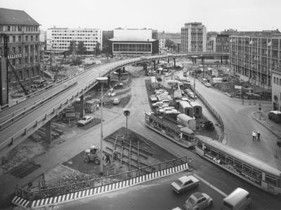
Mit dem U-Bahnbau wurde die Stadt buchstäblich umgegraben. Das galt auch für den Aegidientorplatz. Um den Autoverkehr zwischen Schiffgraben und Friedrichswall trotz Baugrube weiterlaufen lassen zu können, wurde eine zweispurige Stahlhochstraße errichtet. Seit 1968 sorgte die 617,5 m lange „Aegi Hochstraße“ dafür, dass dieser Abschnitt des Cityrings weiter in Betrieb bleiben konnte.
Nach Ende der Bauarbeiten in der Erde sollte die Hochstraße eigentlich wieder verschwinden. Allerdings erwies sich das Provisorium am „Aegi“ als ebenso praktisch wie die schon bestehende Hochstraße am Raschplatz. Nur als Übergangslösung gedacht, prägte die Straße über den Aegidientorplatz bis 1998 das Stadtbild.
Aegi Hochstraße
The construction of the subway literally dug up the city – and this was also true for Aegidientorplatz. In order to keep car traffic flowing between Schiffgraben and Friedrichswall despite the construction pit, a two-lane steel elevated road was built. From 1968 on, the 617.5 meter long “Aegi Hochstraße” (Aegi Elevated Road) ensured that this section of the city ring road could continue operating.
Once the construction work underground was complete, the elevated road was supposed to disappear again. However, the temporary structure at the “Aegi” proved to be just as practical as the existing elevated road at Raschplatz. Meant only as a temporary solution, the road over Aegidientorplatz ended up shaping the cityscape until 1998.